Terrain and plot in your building planning
In each new project, the software first creates a 3D solid for the terrain. This solid is always rectangular and can only be adjusted in size and position via its properties dialog.
All terrain elements, such as the terrain itself, the plot, terrain areas such as beds, paths, etc. are inserted on the ENVIRONMENT layer by default. And they should stay there.
In general in our software, you can only select and edit elements if the layer on which they are located has been marked as the active element in our project viewer on the right side of the software.
Keep in mind that each view maintains its own visibilities and active layers. So first activate the ENVIRONMENT layer and then select the terrain.
In addition to the basic properties of the terrain and the elements that are on or in it, there is also the option of changing the surface of the terrain solids with so called height points or height lines. This is always necessary when the terrain is not flat but, for example, is a property on a slope.
More topics
- Navigation in 2D / 3D
- Create Floor Plans
- Windows and doors
- Insert stairs
- Copy Floors
- Roof Construction
- Building Plans
- Section views
- Elevation views
- 3D Floor Plans
- Become a 3D Architect
- Loft conversion
- Fire Escape Plans
- 2D Symbols
- House Plan Layout
- 3D Constructions
- Home Design Software
- Using 3D Objects
- Using Textures
- Material properties
- 3D Visualization
- Timber frame
The terrain properties
As already mentioned, you can adjust the size of the terrain via its properties dialog.
As this is not the plot, the exact dimensions are not that important. Just make sure that all other elements such as paths, height points, the plot, etc. do not lie outside the terrain solid.
And that the height points not too close to the edge or even exactly on the edge.
As this is not the plot, the exact dimensions are not that important. Just make sure that all other elements such as paths, height points, the plot, etc. do not lie outside the terrain solid.
And that the height points not too close to the edge or even exactly on the edge.
Height points in a terrain and height above sea level
With height points, you deform the surface of the terrain in order to reproduce the course of the terrain around your building.
Height points can have positive or negative values, which you then enter in our numeric fields as usual with a minus sign.
The altitude itself is not the altitude above sea level. It is therefore not intended to generate height points of, for example, 800 m, even if your building is at this height.
Instead, use relative values around zero and then work your way through the terrain with positive and negative height points.
You can set the value zero, for example, at the level of the ground floor or at the entrance door.
If you want or need to specify the total height above sea level in section views, specify the base value of the height in our terrain dialog.
The software then adds the relative height level to the base level and in sectional views and shows the level as 802.80 m. Just as an example, if the base height is 800m, the ground floor is 2.8m high and you set a level marker at the top of the ground floor ceiling.
Plot
Within the terrain solid you can create an element that is shaped and named to represent the exact contour of your property. The property must not be off-site the terrain.
In the properties dialog of the plot you can set the display of the border for 2D and 3D views if required.
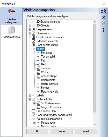
Plot and terrain are independent and can also be displayed separately using the visibilities options in our views. So it often makes sense to switch the terrain solid to invisible at the end of the planning, i.e. when you have drawn all elevation points, all beds and paths. This is done as usual by right-clicking in the view, opening the visibilities dialog via the context menu and making your selection in the Terrain category.
Excavation for the building in our terrain
The software automatically creates an excavation for the building in the 3D terrain solid.
In doing so, it forms its own 3D body along the outer contour of your building and then mathematically subtracts this from the 3D solid of the terrain so that a suitable recess is created.
In case of special features of your building, e.g. individual, protruding walls in the facade or other elements outside the building below ground level, such as an outside staircase, you would have to rework them with a 3D subtraction solid of the 3D constructions plug-in.
Visual Building Basic

Has been developed as an easy to use design and visualisation tool for self builder,extentions..
£60.00
List price
List price
£39.00
Special online offer
Special online offer
Visual Building PRO

Used by all user groups specifically to create professional plans...
£120.00
List price
List price
£99.00
Special online offer
Special online offer
Visual Building Premium

Our most powerful design and visualisation tool specifically created for ...
£180.00
List price
List price
£149.00
Special online offer
Special online offer


